Site staff at several of our terrestrial sites take a fixed point photo each time they visit. Our fixed point photo archive is a unique pictorial record of the conditions at these sites. The longest record, for Moor House in the northern Pennines, spans a quarter of a century and visually charts the varying weather conditions at the site as well as the state of the Trout Beck river and the surrounding moorland vegetation. The pictorial record for Wytham Woods in Oxfordshire is almost as long, and documents the changing seasons through the images of the deciduous trees, from bare branches to buds, full summer leaf and the rich colours of autumn. The collection of images from the Cairngorms vividly illustrates how the landscape has changed as coniferous saplings on the hillside have grown into mature trees. In contrast, the view across a grassy field at Rothamsted to a tree on the far side has changed very little in almost two decades.
The galleries
Viewing the galleries
- First choose the gallery you wish to view from the links below
- In a gallery, click on a thumbnail image to view. Thumbnail images are arranged in sets; click the circles (if displayed) to move between sets. You can also click and drag (↔) the left and right edges of the main photos to move between them.
Moor House
Latest photo: 25 March
- Open Moor House 2026 gallery
- Open Moor House 2025 gallery
- Open Moor House 2024 gallery
- Open Moor House 2023 gallery
Rothamsted
Latest photo: 8 April
- Open Rothamsted 2026 gallery
- Open Rothamsted 2025 gallery
- Open Rothamsted 2024 gallery
- Open Rothamsted 2023 gallery
Wytham
Latest photo: 18 March
Cairngorms
Latest photo: 6 August 2025
You can also obtain ECN data from our physical, chemical and biological monitoring
More about these fixed point photos
Our fixed point photos are available for environmental research and education purposes. Please contact us if you are interested. Currently you can find images from August 2023 in these page, but the complete collection is as follows:
- Cairngorms: 21/12/2000 - present
- Moor House: 24/09/1997 - present
- Rothamsted: 16/01/2004 - present
- Wytham: 25/02/1998 - present
- Alice Holt Forest: 25/06/2010 - 24/02/2016 (images not shown below)
- Yr Wyddfa / Snowdon: 05/01/2000 - 25/4/2018 (images not shown below)
Note that there are some gaps in these collections, and the frequency at which images are taken has varied.
Earliest photos
These are the earliest fixed point photos we have for these sites:
Cairngorms (21 December 2000):
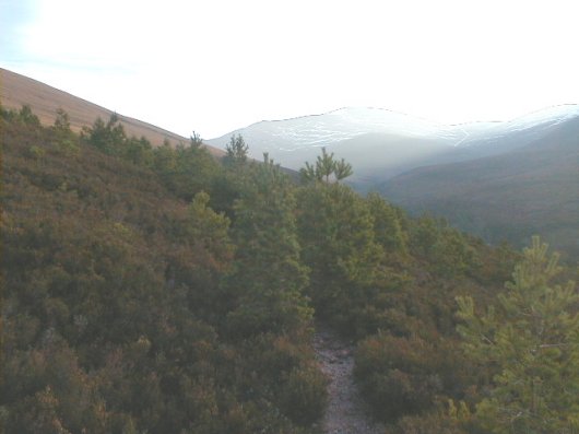
Photos are taken looking up the catchment of the Allt a 'Mharcaidh. When we first began recording this view the summit of Geall Carn (920 m) was visible on the right and, in the centre, the highest summit, Sgoran Dubh Mor (1111 m). These summits are often obscured by cloud. Tree colonisation due to reduced levels of deer grazing is an important feature of the site and mature trees now almost completely obscure the view of the surrounding mountains. The ECN Target Sampling Site (TSS) is on the ridge to the left of the photograph, at 700 m.
Moor House (24 September 1997)
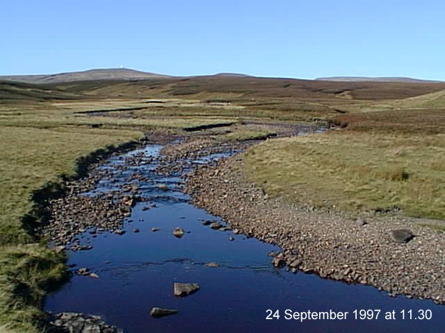
This is a view over the Trout Beck towards Great Dun Fell and Cross Fell. The view is westward from a point (Grid Ref NY756334, Altitude 540 m) overlooking the Trout Beck at its junction with Nether Hearth Sike. In the middle distance is Shaft Hill (0.5 km away) where many of the ECN terrestrial measurements are made. The vegetation is dominated by ling heather (Calluna vulgaris), cotton grass (Eriophorum spp.) and Sphagnum moss, on blanket peat up to 3 m thick. On a clear day three distant hill tops are visible. To the left of Shaft Hill is Great Dun Fell (847 m altitude, 4.8 km away) which has a radar station at its summit. This is the highest point on the reserve and the second highest point in the Pennines. In the centre of the picture and only just protruding above Shaft Hill is the flat top of Little Dun Fell (842 m altitude, 5.2 km away). To the right is Cross Fell (893 m altitude, 7.0 km away) which is outside the reserve and is the highest point in the Pennines. The Pennine Way Long Distance Trail passes over these three summits.
Rothamsted (16 January 2004)
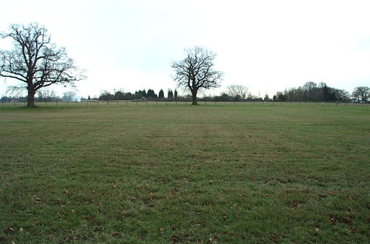
At Rothamsted the majority of the ECN protocols are centred on the Park Grass long-term grassland experiment with its history of botanical and ecological monitoring going back over 150 years (est. 1856). The photograph is looking across Plot 3, Section d (foreground) of Park Grass. This plot is of interest to the ECN as it receives nil applications apart from those coming from the atmosphere. As you look further towards the background sections c, b, and a have received differing rates of agricultural lime (chalk) and have different plant communities from that of Plot 3, section d.
Wytham (25 February 1998)
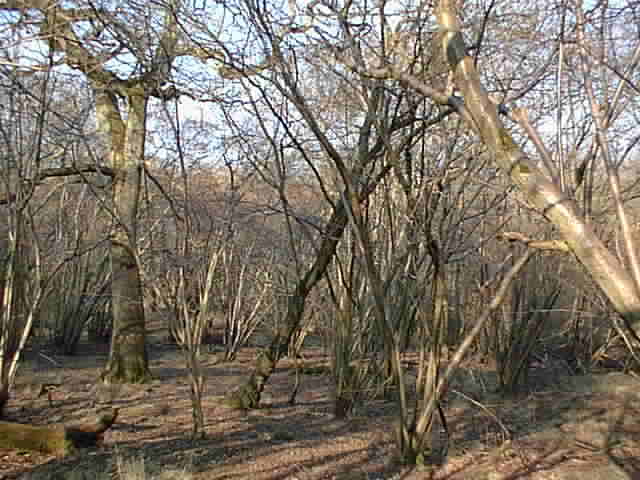
The photograph is taken within the ECN Target Sampling Site (TSS) located on the northern side of Wytham Wood (U.K. National Grid Reference SP45 09, altitude 65m). The TSS is located in an area of ancient woodland (believed to have never been cleared) with abandoned hazel (Corylus avellana) coppice with oak (Quercus robur) standards (full height trees). The soil is a deep heavy clay (Denchworth series) which is often waterlogged in winter. The photograph shows the multi-stemmed hazel stools with an oak standard on the left-hand side. To the left of centre there is a willow (Salix caprea) leaning across the picture, with a small hawthorn (Crataegus monogyna) tree behind it. The grass is mainly Tufted hair-grass (Deschampsia cespitosa) with some Wood false-brome (Brachypodium sylvaticum). The dead wood is left where it falls.