As air masses move around the globe, so air pressure changes. Areas of high pressure are called anticyclones, whilst low pressure areas are known as cyclones or depressions. Each brings with it different weather patterns. Anticyclones typically result in stable, fine weather, with clear skies whilst depressions are associated with cloudier, wetter, windier conditions.
This image from the UK Met Office website shows high (H) and low (L) pressure systems around the UK and Europe:
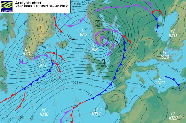
[Source: UK Met Office]
Facts and questions
- Notice the thin lines on the map. These are called isobars. They connect areas of equal pressure, in the same way that contour lines on a map link places of equal altitude. Where isobars are close together (often around a deep low pressure system) the winds are strong.
- Looking at the map above, can you tell whether there is high or low pressure located north-east of the UK?
- The unit of air pressure shown on the map is hectopascals (hPa). What is the difference between the lowest pressure and highest pressures shown?
- If an isobar links areas of equal pressure, what do you think an isotherm links?
- Look at the isobars over the UK. See how they are close together. The winds this day (4th January 2012) were strong. The day before they were even stronger, and caused significant travel problems and damage to buildings, as you can see in this BBC news story. Sadly two people were killed.
This table summarises high and low pressure systems
| High pressure system | Low pressure system | |
|---|---|---|
| Also known as: | Anticyclone | Cyclone or depression |
| Characteristic weather conditions in the UK: |
|
|
| Learn about anticyclones... | Learn about depressions... |